Taroko Gorge | Taiwan
If music is liquid architecture and architecture is frozen music, as Johann Wolfgang von Goethe said, then Taroko Gorge is both architecture and music. A breathtaking combination of solid rock and rushing water, Taroko Gorge deserves its reputation as a world-class natural attraction. Since a strong earthquake on the morning of April 3, 2024, however, most of it has been closed to the public. It’s possible that some spots within the national park, such as Changchun Shrine, Buluowan Lower Terrace, the Tunnel of Nine Turns trail, and the Tianxiang area, could reopen before the end of 2024 — but this depends on the progress of repair work and whether the summertime typhoon season brings any destructive storms.
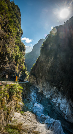
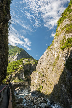
This not-to-be-missed geological marvel is located in the eastern part of Taiwan, a rugged island that punches far above its weight in terms of mountains and ecological diversity. Wandering through the 19 km-long (12 miles) gorge, one can’t help but stare at the cliffs high above, then gaze down at the boulder-filled Liwu River.
A world-class natural attraction
Because Taroko Gorge is a treasure chest of marbles, schists, and gneissic rocks, the colour scheme includes creamy whites, dark greys, light browns plus soft shades of silver and gold. And then there’s the foliage which thrives in all but the most vertiginous spots, as well as the hemlock, spruce, cypress and pine forests that cover more than four fifths of Taroko National Park.
The only road through Taroko Gorge is the Central Cross-Island Highway. Completed in 1960 by demobilised soldiers who’d followed Chiang Kai-shek when he withdrew from the Chinese mainland more than a decade earlier, it’s a spectacular but challenging ribbon of tarmac. Drivers may feel nervous, but for passengers it’s a thrilling succession of eye-popping sights. Glimpses of sheer rock faces and azure streams are followed by intoxicating, as-far-as-the-eyes-can-see mountain vistas.
The layers of rock which form the floor and sides of Taroko Gorge began to take shape tens of millions of years ago with the accumulation of sediment and lava beneath the Pacific Ocean. These deposits, often over 10 km (6 miles) deep, were hardened by metamorphism. More recently — a mere 6.5 million years ago — the Philippine Sea tectonic plate began to collide with and slide beneath the Eurasian plate, pushing up the edge of the latter and causing the tilted rock strata evident in many parts of Taiwan.
Around 2 million years later, the landmass we now call Taiwan emerged from the sea. Rivers quickly formed, and these waterways began chiselling down through the rock. Erosion continues at a steady pace, but because Taiwan’s tectonic uplift rate is one of the world’s highest (more than 5 mm per year until 5,000 years ago; an average of 2 mm per year since then), the riverbed at the bottom of the gorge is in fact rising by a tiny amount each year.
Beyond the gorge
Taroko National Park stretches from sea level to the top of Taiwan’s fifth-highest peak, Mount Nanhu (3,740 m / 12,270 ft), giving this spectacular conservation zone tremendous climatic variety. This in turn has nurtured fabulous biodiversity: More than 250 kinds of butterfly are active and visible. There are 34 mammal species, among them the Formosan Macaque (a type of monkey found only in Taiwan) and the goat-like Formosan Serow. For birdwatchers, the most exciting of the park’s 140-plus recorded avian species are endemics such as the Blue magpie (Urocissa caerulea), the White-eared Sibia (Heterophasia auricularis) and Styan’s Bulbul (Pycnonotus taivanus).
Even for those who wish to stay close to their vehicle, the Taroko area offers an abundance of impressive sights. Changchun Shrine (Eternal Spring Shrine) was built as a memorial to construction workers who lost their lives building the Central Cross-Island Highway. It’s a colourful Chinese-style place of worship named after and built atop a water source that never dries up. It’s possible to hike from here to a cave named in honour of Guanyin, the Buddhist goddess of mercy, a bell tower, and a Zen monastery.
Rightfully regarded as a highlight, Swallow Grotto is one of the narrowest, deepest and most extraordinary sections of the gorge. Grit and stones carried downstream when the Liwu River floods have pock-marked the cliff face here, leaving dozens of cavities in which birds nest, hence the name.
A few sections of the highway have been straightened for safety reasons, and one stretch of former road is now a walking trail which gives sightseers a chance to slowly appreciate the Tunnel of Nine Turns and views from it up and down the gorge. The route, as much overhang as actual tunnel, has far more than nine twists and turns; the ‘nine’ in the place name is a classical Chinese way of expressing ‘many’.
Discovered by Japanese soldiers during the colonial government’s 1914 campaign to subdue the indigenous people, Wenshan Hot Spring remains undeveloped. The only facilities are a changing room; access is from the highway is via stone steps and a footbridge. The geothermally-heated water which seeps out from the rock face is scalding hot, while the adjacent river is often numbingly cold. Because visitors have been injured by falling rocks, the national park strongly advises tourists not to approach the hot spring; fences and warning signs have been added to keep people out. Entering an officially-closed section of the national park could result in a stiff fine.
Gentle strolls, invigorating walks, and demandin
Popular hiking options
A popular leg-stretcher is the Shakadang Trail (4.5 km / 2.8 miles; indefinitely closed due to the 2024 earthquake), named after a tributary of the Liwu which drains from north to south. Much of the path is a broad concrete track which shadows the stream; the gradient is gentle. Most visitors spend two to three hours on the trail, but it’s possible to go further afield if planned in advance.
Often described as Taroko Gorge’s most challenging and rewarding hike, Zhuilu Old Road (10.3 km / 6.4 miles; also closed for the time being) is misnamed. It was never wide enough for cars, and in places it’s so narrow fast hikers can’t overtake slow walkers. This trail was cut into the hillside almost a century ago and is high above the current highway. Those brave enough to tackle it are rewarded with incredible views of the valley, but need to be in tip-top physical condition.
The family-friendly Lushui Trail (2 km / 1.25 miles; closed at the time of writing but may reopen by spring 2025) also predates the modern highway. It’s hardly changed since the Japanese colonial authorities widened a hunters’ track so military equipment could be moved by porters pushing wheelbarrows.
The little settlement of Tianxiang — location of the area’s most luxurious hotel — is at an elevation of 480 m (1,575 ft). Most of those who call Tianxiang home are Truku, members of one of Taiwan’s 16 indigenous tribes. Like Taiwan’s other Austronesian aboriginal groups, the Truku share linguistic and genetic kinship with the natives of Polynesia, Hawaii, and New Zealand. The tribe’s name is derived from that of the gorge, although the word ‘taroko’ (which means ‘magnificent and beautiful’ in the Truku language) initially referred not to the ravine, but to the stunning views of the Pacific Ocean which greeted those who emerged from the gorge’s eastern end.
From Tianxiang, a very short but steep trail leads to a small plateau where there was once a Truku village called Tapido. The much longer excursion to Huoran Pavilion (1.9 km / 1.2 miles) involves considerable altitude gain if tackled from Tianxiang, but rewards those who take on the challenge with superb views from a high ridge. Starting less than 1 km inland of Tianxiang, the Baiyang Trail (2.1 km / 1.3 miles) features no fewer than seven short tunnels. These cut through the mountain, delivering walkers to one of Mother Nature’s sweet spots: Baiyang Waterfall and the gorgeous creek into which it cascades. Even before the April 3, 2024 quake brought devastation to the area, trail closures were frequent, especially in the wake of typhoons.
One of the great things about Taroko Gorge is there’s no bad time of year to visit. Still, each season has particular advantages. During summer, wildflowers and butterflies are exceptionally abundant. The Liwu and its tributaries are spectacularly vigourous, yet there’s a greater chance landslides may damage hiking trails or even the main road. The gorge never gets as hot as Taiwan’s cities, and there’s no shortage of shade. November to April has the driest weather. Even during the coldest months of December, January and February, temperatures in the gorge are a comfortable 11 to 20 degrees Celsius (52 to 68 degrees Fahrenheit).
Several recommended destinations are within a day’s drive of Taroko Gorge. The road that passes close to the main peak of Hehuanshan, (Taiwan’s 34th highest mountain at 3,416 m / 11,207 ft) leads to Sun Moon Lake via Qingjing Farm. An alternative route takes in the high-altitude fruit-growing town of Lishan, within striking distance of Shei-Pa National Park. Taiwan’s glorious east coast and East Rift Valley begin just south of the gorge, and await those with the time to explore every corner of Taiwan.


